Click on the trail you want to follow:
1. Trail of Catalina Island
2. Bayside Trail- Cabrillo National Monument
at Point Loma , San Diego
3. Border Field Park to Imperial Beach, San Diego and hearty bag lunch recipes
4. San Clemente Pier to Trestles Beach, Orange County featuring beach party recipes
5. Mountain Biking Sycamore Canyon Preserve/Goodan Ranch, Poway San Diego (Coming soon)
![]()
Trail of Catalina Island

Sally
Clements, tall and upright, stands on her porch high up on the
hillside. A woman of few words, her eyes fixed on the tiny Avalon Harbor,
she keeps track of the Island comings and goings, even now at 91. People
scurry away from the dock below pulling suitcases behind them just as we did several
hours before. There is a rhythm to Catalina Island drummed out by the arrival
and departure of boats. Sally knows this beat, like the tide, has felt it
for fifty years, 25 years as the Matron of Police.
Departure from Dana Point Harbor

We
queued up on the platform next to our red cooler on wheels, 2 duffel bags
and a small rolling suitcase. I snapped pre-departure pictures with a new
telephoto lens, a birthday present from T.M., my husband, Scott. Before
departing on the Catalina Express boat, I ducked into the Jolly Roger
restaurant for tea. Recognizing the pictures on the wall as the same as when
I was vacationing here, some twenty something years ago, I was suddenly
nostalgic. This once favorite breakfast spot had served sourdough toast - simply
unheard of in Minnesota restaurants. The Dana Point Harbor played as
a backdrop for my California dream then. Fifteen years now had passed since that
dream was realized, making San Clemente, California our home. All our
immediate family has now escaped the bone-chilling misery of endless
winter, hot, humid, short summers and a mosquito population on par with
Bombay, India.
I
had not been to Catalina since my nephew, then 5, made my sister's life miserable
by snatching toys away from other tots on the tiny Avalon beach. Though
visible from our home in San Clemente on a clear day, T.M. had never been to Catalina. It
was a faded memory to me, a shrouded mystery to him.
We
shoved off into the gloomy morning face of the Pacific Ocean. Quickly all
distinguishable land forms disintegrated into particles of gray haze.
Gunmetal gray clouds spat mist. The boat churned up a wake like
white smoke on the gray smooth ocean. Gray
birds flew toward a gray horizon. I pictured us capsizing; flotsam doomed to
bob up and down in that grayness, lost in the Pacific Ocean, the largest
physical feature on earth.
Avalon Harbor

Just when I had surrendered to this stern gray shroud, the ocean smiled with ice blue teeth. Brilliant sunshine illuminated plunging cliffs, broad chaparral-covered canyons and clear turquoise water. Hillside homes burned with hot pink, yellow and turquoise paint.
Glenmore Hotel
Our yellow and purple Victorian hotel
just off the main street looked inviting. We climbed up three
sets of stairs and wound down the narrow airless hallway of the old,
Glenmore Hotel. It rang a bell for me with its similarity to the hallways of the
Hotel Del Coronado in San Diego and I wondered. Did it have ghosts too? Our
tiny room was barely big enough to turn around in. The walls screamed fuchsia
pink, no doubt to divert from our myopic view from the windows. We peered down an
alley to a distant side street. From the other, we could lean out and nearly
touch the building an arm's length away.
But we were lucky to have one of the last rooms at the hotel. The jazz festival weekend, requiring a 3-night minimum,
had filled most of the hotels in town.
Sally Clements

We
were not here for the jazz festival but at the invitation of Sally
Clements’s grandson and his wife, with a promise to show us around Catalina. Growing up,
her grandson had spent time helping his Grandfather who was brought over to run the
famous Casino theatre. He recalled helping paste up movie posters around
town. Up the steep hill we climbed and then climbed a triple staircase to
meet his grandmother at her green porch watch post. Not only did she "keep
the peace as Catalina’s police matron for twenty-five years, she
was the very first Los Angeles County female sheriff," she said
proudly! Her badge hung on the porch wall. "No, she never carried a weapon." I was anxious to know more but something
strange happened. Like Snow White, we were enchanted;
sleepiness came upon all of us. We fell silent. We looked out over the
harbor and we said nothing to each other finding really there was nothing
that needed to be said.
T.M. retired for a nap back in our hotel room. I headed for an outdoor café to
shake off the lethargy with some caffeine. Sipping British Breakfast tea, I
gazed at the now empty Crescent beach where my nephew once played. How had
all this time passed by? He, now 23, was married to a deputy sheriff like
Sally. Avalon now had many more buildings than I remembered. T.M. said
Catalina reminded him of New Orleans and I thought in many ways it had the
flavor of downtown Palm Springs where the mountain towers above the streets.
Set free by the boat we were now confined to the Island. She began to unfold
to us but only on a need-to-know basis.
Massive cliffs rising hundreds of feet on both sides of Avalon
form
a strong set of shoulders for the little bay. They felt solid and right. The
sky, a steel gray prison wall, revealed only a little beyond that
bay. Behind that stern wall the California coastline lay hidden, forgotten.
What was this strange malaise? Boat anchors weighed down arms and legs. I was wilted lettuce, two-week-old celery. Eyelids drooped like a cat's in the afternoon sun. Then I knew! I had seen it in Sally’s tranquil eyes earlier. Catalina Island had settled into my nervous system.
We’d arrived
pacified, rocked by the great ocean. The sweet, simple town could be taken in
at one sweeping glance. Everyone walked or rode in a golf cart. Fight or
flight instincts not operating, my body hadn't recognized the Island’s
hypnotic effect.
Dinner and the Casino theatre stroll
Our
host, a Culinary School graduate and award-winning chef, chose Armstrong’s
for dinner. After an excellent scampi and swordfish meal, we aimlessly
strolled the street ambling along the brick and tile Via Casino Way to the
landmark Casino theatre filled with jazz fans. We were only able to peek in
and admire the floor to ceiling Mermaid Mural floating in pink grandeur
across the entrance. We circled outside and he pointed out the back door
which he and grandpa had used and where they used to fish, “Over there,”
he
indicated the dark water. But he said, “Fishing is restricted.” That
Island malaise set in again and we retired as the strains of smooth jazz
oozed out of the Casino. People who like smooth jazz stay up late. Very
late!
Sleepless night
T.M.
drifted into deep sleep immediately. Revelers
spilled out onto the streets for most of the night and tromped up our four flights of stairs
punctuating each arrival with a door slam. Tromp tromp tromp tromp tromp
tromp tromp tromp tromp tromp tromp-slam! Tromp tromp tromp tromp tromp
tromp tromp tromp tromp tromp tromp-slam! They tromped in groups of two and
four and five. Finally, around 3:30 they stopped.
The
next morning, I asked the desk clerk for a room that was not next to, above
or under a staircase. “Nothing available.”
“Oh,
yes, I know, of course the Jazz Festival,” I said. I requested a floor fan for white noise and an extra pillow
to put over my head. He promised to deliver and we set off for the morning
hike.
Morning Hike
All
roads lead to Avalon Canyon Road. We walked 1/1/2 miles from the
harbor to the road's end. We passed the ball fields and clubhouse used by the
Chicago Cubs for spring training for 26 seasons starting in 1921. Chuck Connors,( late TV star of The Rifleman)
played for the Cubs and Sally's
grandson recalled his grandfather, Tommy Clements, fished with him
during Spring training. In our
mind's eye, players ran bases while beat reporters sat watching William
Wrigley’s team. We joked about the players from the past walking out of
the green foliage as in Field of
Dreams.
Botanical Gardens
Inside
the Botanical Gardens, the collection of rare and endangered Catalina Island
endemic plants stole all my attention. The Catalina Live-Forever, Dudleya
hassei, shot up lanky flower stalks from a cluster of thick succulent
dusty-gray leaves. Knowing one passed plants that only grow here in this one
place on earth on these dry rocky slopes makes one pause and admire their
rare appearance. We clomped over a wooden bridge and slipped into a hushed
tree-bowered grotto where Catalina Ironwood, Lyonothamnus
floribundus floribundus, and Catalina Mahogany, Cerocarpus
traskiae,
grow like gnarled old dry twisted fingers. The garden planted
here was the brainstorm of Ada, the wife of the chewing gum magnate, William
Wrigley, Jr. It is said Ada also picked the location of the Wrigley home as
the place where the sun first touched the shoulder of Avalon.
Wrigley Memorial

The Wrigley Memorial, honoring the man whose vision preserved 88% of the Island, loomed Roman ruin-like above us. We started up the 80 steps. Staircases were becoming a theme on this trip!

Born in 1861, in 1919 William Wrigley Jr. bought a majority interest in the Santa Catalina Island Company. Preservation of a big chunk of the Island’s 76 square miles of plunging cliffs, broad canyons and clean coastline was his deam. In 1975, the Wrigley family donated 88% of Catalina to the Santa Catalina Island Conservancy. His treasured vision now allowed us to experience the Island much as he did.


The stone monument, created mostly from Catalina materials, afforded clear views of the Avalon Valley and harbor but no farther. It was not a ringing clear-blue day where we might have seen our hillside in San Clemente. That prison wall of gray blocked all view beyond our Island harbor.

Wrigley
Memorial Trail
The road wound up the Wrigley Memorial Road Trail. As others with more sleep marched far ahead of me, I started at a whoosh near my head. Seeking the source of the sound, like silk rubbing against silk, I turned to witness a common raven, Corvus Corax, circling on air currents between the canyon and myself.

Divide
Road Trail to Hermit Gulch Trail
Eventually a pinnacle was reached where we viewed the other side of the Island surrounded by dark blue open water, nothing between Hawaii and us now. After about 3 hours and 6 miles of hiking, the trail dropped us down to Hermit Gulch campground and to the head of the Canyon. Though very hungry, we hiked the extra ½ mile out to Pebbly Beach for a recommended lunch at the Buffalo Nickel.
For the return trip to town we hailed a taxi. The ease of walking in Avalon attracts us. The automobile has stripped nearly every California town of walking/gathering places. The price of convenience is a gobbling up of land for parking lots, freeways and roads that used to be for people. And surely, William Wrigley Jr. foresaw a need to protect this Island from sprawl.

Sunrise
The next morning, I rose early and I must say well rested. The dutifully delivered fan and pillow had muffled all the night’s tromping. As the sun rose on the little curve of crescent beach, the sand still held the evening coolness. The tarry aroma of the wooden pier pylons mixed with the sea breeze and the idling diesel boat engines. The saltwater tang, vital and clean, spoke of fresh fish. Not a whiff of stagnant water.


The blue-pink light first hit the Casino on Sugarloaf Point. The walls, golden pillars, punctuated the flank of the hillside like a shining beacon. On a clear day its luminescent shape is visible on the mainland. The musical clank-clank of sailboat masts played in the light breeze. A dull gray seagull planted himself between my lens and my subject building. He squawked and strutted indignantly. “Why have I no bread for him?” He then became my subject until another pushy seagull took over. “And why have I no bread for him?”


As hungry as the birds, I headed for the breakfast rendezvous with the others at the Pancake Cottage. T.M. ruminated about not sleeping well, hearing an all night party, seemingly right next door. “What party?” I asked.
When asked, how they had enjoyed yesterday’s hike, Sally’s grandson surprised us by confessing though he found the hike “exhilarating, refreshing and beautiful, it was the farthest he had ever walked in his life!”
“The views from the top” his wife said, “worth the climb.”
T.M appreciated the lack of litter on the trails and the tranquility away from the town commerce. I felt I knew what Ida and William Wrigley Jr. loved from the hike, and saw the open land part of his great conservation vision.
Golf Cart Tour and last minute shopping
Luggage in the lobby ready for boat departure, I just happened to mention I am writing this article to a new friendly desk clerk. He handed me a sheet on the history of the hotel. I tucked it away to read later. While last minute shopping, I discovered a book, Haunted Catalina and The Story of Catalina Island. And we purchased a real piece of Catalina. Catalina tile that is.
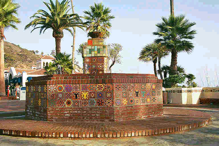

The Catalina tile artistry restored by Richard Thomas Keit Studios refurbished many of the city’s landmark buildings; the Via Casino archway and the Mermaid mural at the entrance to the Casino. Striking tiles reflecting the colors of the Island decorate fountains, restaurant facades and store fronts. The effect achieved is to unify Catalina with a stunningly harmonic theme absolutely defining Avalon’s uniqueness and once more stamping Wrigley’s genius on the Island. He brought over artisans to design tiles at his pottery production facility in 1930. At the Perico Gallery we picked out several tiles with thoughts of setting them into our fireplace at home.
Our
1-hour scenic golf cart drive zoomed us back out Pebbly Beach Road up and
over Avalon’s broad shoulders past Mount Ida, past the Zane Gray hotel and
over to Sally Clements’s house for a farewell.
“Would
she ever leave?” I ask.
“No!
Never. Going to the mainland is so tiring.”
We went back to gazing out over the harbor for our soon to arrive Catalina Express. I signed her guest book dating back to the 1960’s. Her grandson showed us his scrawling 6-year old signature. Sally handed her grandchildren a recent article written about her. She recalled how Wrigley had gotten the police a paddy wagon, once owned by Al Capone. And back in 1958 the first girls who dared to bare themselves in bikinis on Crescent Beach were given a yellow ticket by the judge and sent home on the boat! The article said one time Sally spotted a golf cart with 5 people riding in it. Though the man in the offending cart protested saying he was a Los Angeles sheriff there to give her a commendation, she wrote the ticket anyway. I told her of my nephew’s wife working in the jail, conflicted about not being able to help the inmates. “Oh, yes,” she said with experience, “You can’t give them a break.”
We stared past the white crème walls and rolled bamboo shades to the harbor; then left her waving from the steps and on her way to church.
Catalina
Express back to Dana Point Harbor
As we jetted away from the Island, I shot pictures of the village fading away, and then settled in my seat in the front of the boat to read the paper on the Glenmore Hotel. Shockingly the ghostly Glenmore history revealed itself.
Glenmore Hotel History Revealed
I read the exciting details to my companions. We mused about why the hotel hadn’t made a great big deal about it being the second oldest hotel in California! There was a connection to the Hotel Del Coronado in San Diego. The work crews from the Del in San Diego came here to complete this hotel in 1891. And as for famous people, not only had Charlie Chaplin and Gloria Swanson rented out the fourth floor for long periods of time, other guests included Clark Gable, aviator Amelia Earhart and Teddy Roosevelt! And why did we not see one plaque or publicity about this?
The Haunted Catalina book’s chapter on the Glenmore gave many reports of ghostly activity. A report of a loud party going on in a room, only for the management to find the room to be empty. Is that what T.M. heard? Other strange events involved the room next to the lobby area and reports of phantom smoke and flames shooting out of the building. The hotel had survived the ravages of the 1915 fire that destroyed much of the town. To my disappointment there was no mention of tromping ghosts on the staircases. We read about the Chicago Cubs spring training ball fields. A caretaker reported an encounter with a ball player in vintage uniform who disappeared into thin air. Catalina was showing us her mysterious side.
I stood outside on the bow with my back to the brisk rushing wind, my eyes fixed on sunlit Catalina. White clouds began to obscure the sun. Scott sat on a buoy and together we watched as the Island walled itself off, revealing nothing, disintegrated into the haze. The hills were no longer sharp, sunlit shoulders but distant land devoid of details. We were on the other side of that gray wall. We turned to face into the wind and toward the southern California mainland.
The landform of Long Beach emerged like a crouched cat collecting clouds along an arched back. Two teenage girls, hair flying, belted out Yellow Submarine over the din of the engines cutting through black liquid obsidian water. I longed to see the gaping blue mouth with ice blue teeth but gray it was once more.
The mainland looked to be completely unpopulated. The ocean water changed from black to an opaque Concord grape hue. One by one the coastline cities became distinguishable, New Port, Laguna Beach and finally Dana Point with the backdrop of Saddleback Mountain. Unbelievably, on the hillside illuminated by a patch of sunlight, I could see the pink tile roofs of my own neighborhood in San Clemente! At the dock we are told the weather was rainy, cool and gray all weekend. They couldn’t believe the sun shined on us in Catalina every day!
Later that week in San Clemente, the prison wall of low clouds lifted and the outline of Catalina Island could be seen. We smiled at this once mysterious apparition, now knowing the details of those lovely shoulders, the trees and plants growing in the canyons, the heart of William Wrigley and the tranquility in Sally’s eyes.
Travel
notes:
Catalina Express 1-310-519-1212
Wrigley Memorial Garden open 8 am – 5 pm year round. Admission fee $3.00.
Hikers must obtain free use permit from the Catalina Island
Conservancy. Available at:
Conservancy House, Avalon,
125 Claressa Ave. Open 9am – 5pm Weekends close for lunch. Trail map
available for 50 cents. Information 1-310-510-2595
Interpretive Center, 1 mile up Avalon Canyon across from Campground. Open from 9am –5pm Information 1-310510-2514
Mountain biking policy. Permits required at a fee of $50 per person and $75 per family (spouse and minor children.) Valid from date of purchase to following April 30. Prorated quarterly beginning May 1. Fee includes coverage for accident, liability and life insurance while riding on Catalina.
Glenmore
Hotel 800-4-CATALINA email Glenmore@glenmorehotel.com
Perico Gallery, Metropole Market Place, 310- 510-1342
Copyright 2000 Linda McMillin Pyle Excerpt from
upcoming book Pacific Palms and Picnics: Day Journeys on the Southern
California Coast.
![]()
Trail of Cabrillo
Bayside
Trail, Cabrillo National Monument, Point Loma,
San Diego
Featured recipes: Portuguese Fish Stew and Mediterranean Bread

Seeking the glory and passion of a great explorer, we stand at the most extreme southwestern tip of land in the continental United States. It rises 400 feet above the San Diego coastal plain. The turbulent Pacific fiercely batters the yellow cliffs of the west flank. The calmer water of San Diego Bay tentatively laps at Point Loma’s east side. This solemn green, chaparral-covered point of land remained outside the known mapped world until September of 1552, when the first European expedition to the coast of North America stepped onto its shore.
Juan Rodriquez Cabrillo
Jubilation and foreboding must have filled the soul of Juan Rodriguez Cabrillo as he surveyed this headland from his flagship galleon, the San Salvador. Curiosity and dread must have filled the hearts of the Kumeyaay Indians as they blinked in disbelief at the “houses on the sea,” two caravels and a galleon, flying the blood-red cross of Spain. The Pueblo Indians and Yuman people to the east had already recounted to them terrifying stories of bearded soldiers wielding spears and cross bows. Nervously biting lips they now witnessed these strange mythical conquistadors invading their blue peaceful bay.
As for many explorers what they seek is not necessarily what they find. Ordered by the King of Spain and the Viceroy of New Spain north up the coast of New Spain (Mexico), Cabrillo was to search for a legendary river connecting the Pacific and Atlantic oceans. Then modern wisdom held that California was an island perhaps inhabited by Amazon women. He was to lay claim to all the land as he pushed farther north into Alta, California than any Spanish explorer had ever gone before.
His courage had been tested as a younger man wielding a cross bow against the Aztecs and conquering Guatemala. Already a well-to-do man, forsaking his previous life as landowner, miner and merchant, Cabrillo left behind his wife and children to command a fleet of ships he himself had built for coastal exploration. Three months out of Navidad, Mexico, traveling many leagues and enduring “impeding cross winds, terrible weather, dangerous shallows and reefs, showers, sudden shifts in wind and let ups,” favorable winds finally propelled them into the great curve of today’s San Diego Bay. Staying only 6 days while waiting out a storm before sailing farther up the coast, Cabrillo christened the gentle bay, San Miguel.
Cabrillo National Monument
On the Trail of Cabrillo, we
climb the hilly streets of the ship-shape Point Loma community by car, reaching
the plateau of this high, jagged peninsula. Now occupied by Fort Rosecrans
National Cemetery, we pass by identical white head stones that cross rolling
green hills in symmetrical rows that seem to extend infinitely. Over 49,000
American military service people and their families are honored here. After the
Mexican-American War, the U.S. Army’s First Dragoons killed in the battle of
San Pasquale (about 1 hour inland) were reburied here. Now, as part of the
California Territory, Point Loma belonged to the United States.
The sun struggles to penetrate the sky roofed with gray clouds outside
the Cabrillo Visitor Center. A foghorn blasts notes, dull and lonely, adding to
the morning gloom. Inside, lively spotlighted exhibitions reveal Cabrillo’s
voyage in large dioramas. A model of his ship San Salvador reveals that though only about 100 feet long and 25
feet wide, a crew of around 100 soldiers, sailors and slaves slept, ate, worked
and perhaps prayed on deck next to chickens, horses and sheep. Good teeth were a
necessary attribute for sailors to gnaw on the hard tack biscuits and salted
dried meats. Only Cabrillo and perhaps, Bartolme Ferrelo, chief pilot of the Victoria,
might have had the luxury of private quarters.
As he was known to be a literate man, I picture Cabrillo busily writing
in the ship’s navigational journal by candlelight. His logs have never been
found. Accounts of the expedition have been pieced together by surviving
crewmembers and historian conjecture. Cabrillo’s life is an unsolved mystery.
No one knows his exact age, if his face was handsome or brutish, or even if he
was Spanish or Portuguese!
Inside the glass-walled visitor center the sweeping view of San Diego
floats dizzily by. After thumbing and purchasing books, we sign the logbook
along with travelers from the UK, Germany, Spain and Japan. Outside, walking
along the sandstone cliffs we pause to
push buttons and hear Cabrillo’s story in French, English, Spanish or
Portuguese. Like a kid on a school field trip, I am anxious to run the Bayside
Trail down to Ballast Bay, the very spot where he Cabrillo first made claim of
this coastline for Spain. But first we explore the old lighthouse easily walking
up the road.
The Old Lighthouse
Until 1855, this headland held no welcoming beacon, warning foghorn or cozy New- England style lighthouse. The original lighthouse, in which we now stand, answered the demand for safer passage along this now well-traveled coast. Captain Israel, once a keeper of the light, trimmed the wicks, cleaned the glass and polished the brass. His family’s few comforts on display speak of hardship. A bumpy, 9-mile wagon ride into town for supplies isolated the family; wind and rain battered their small windows.
On a clear night sailors took heed of the beacon reaching 39 miles on a clear night. But today, the low hanging clouds remind of the fog which chronically plagued Captain Israel’s lighthouse, causing unfortunate shipwrecks. A new one, constructed closer to the water in 1891, is now fully automated and still operational.
Bayside Trail to Ballast Bay
Finally, I breeze down the much-awaited old Army road for the 2-mile round-trip trail to Ballast Bay. The fairly steep road drops a total of 300 feet. I quickly lose Mom and Dad as they stop often to explore the military bunkers built as part of a protective ring of defense for the Harbor during World War I and II.
The native coastal sage scrub, spare and endangered, gives a haunting beauty. The heady aromas of Lemonade berry and black sage lift the nose to sniff the potpourri of plants effusing the very unique essence of southern California. Like a thousand bright yellow suns, the encelia Californica, shine next to fiercely spined prickly pear and other endemic plants are protected and preserved in the Point Loma Ecological Reserve. Grazing deer and fast little cottontail rabbits hiding in the underbrush would have made mouthwatering delicacies for the seamen.
Finally, the low clouds depart.
Down at Ballast Bay, I stand in sunlight under a blue sky. Picking up a
smooth stone, I think of Cabrillo declaring this land for Spain.
Perhaps he moved these stones from one pile to another or gathered water
from the bay in a clay vessel then poured it out on the land. These were
customary acts of possession in his day, like our astronauts planting the
American flag on the moon. Goose bumps rise on my arms; my stomach tightens.
Cabrillo’s’ exhilaration and the Kumeyaay dread is still electrifyingly
present in the rolling momentum of the unstoppable ocean waves piercing the
terrible beauty of the sandstone cliffs.
One cannot get this understanding by merely glancing over words on a
printed page. The spirit of place illuminates history like the flickering candle
in Cabrillo’s private quarters on San
Salvador. I comprehend for the first time the passion and glory of a 15th
century explorer and the confusion and fear of the native people of southern
California. As I turn on more time to look out to sea, I feel the Kumeyaay
breathing easier as the 3 ships finally become just an outline inscribed on the
far horizon.
Cabrillo in his day must have had the status of today’s astronaut. His
fast rising star faded quickly. Shipmate’s journals reflect that before a year
had passed, his lifeless body, ravaged from gangrene, would lie buried on a
windswept Channel Island. Again a mystery, scholars don’t agree if a broken
arm or leg killed him or even on which Channel Island he is buried. It is known
that Bartolme Ferrelo, chief pilot of the Victoria,
was ordered to carry on the exploration.
Sixty
years later, Captain Sebastian Vizcaino, attempted to claim discovery of all of
Cabrillo’s former findings along the coast. Against orders, he renamed San
Miguel, San Diego, usurping, for a time, Cabrillo’s rightful place in history. But Cabrillo, the conquistador, has not been forgotten. His
greatest accomplishments are immortalized here at Cabrillo National Monument.
The most extreme southwestern tip of land in the continental United States
connects us, in the Information age,
with the Age of Exploration and the waning glory of Spain.
Post script Recently both of my husband’s parents were buried at Fort Rosecrans near the white stone obelisk.
Travel Notes:
Cabrillo National Monument is located at the tip of Point Loma at the end of State Highway 209 (Also called Catalina Boulevard) From Interstate 5 Freeway take the Rosecrans/209 exit. Take Rosecrans to Canyon Street and turn right. Proceed left at Catalina Boulevard and follow it to the end.
Admission: $5.00 per car, $2.00 per person for walkers, bikers, joggers and motorcyclists. Call for commercial vehicle rates.Hours: Open daily 365 days a year from 9 a.m. to 5:15 p.m.
Information: 619-557-5450.
Bayside Trail is 2 miles round trip.
PORTUGUESE FISH SOUP
The Portuguese were the first to
write recipes into cook books. Using clam juice instead of fish stock makes this
recipe fast to prepare. The sailors probably used dried cod.
2 pounds of fish such as cod,
halibut, haddock, shrimp, sea scallops
1 cup chopped onion
3 cloves minced garlic
1 tablespoon olive oil
16 ounces clam juice
1 cup of a dry white wine
1 pound chopped roma tomatoes
1/8 teaspoon each dried thyme and basil
¼ bay leaf
Freshly ground black pepper to taste
In a large kettle sauté onion and garlic in olive oil for 5 minutes. Add clam juice and wine and bring to a boil. Reduce heat and add fish to pot. Add tomatoes, thyme, basil, bay leaf and pepper. Gently simmer 5 minutes or more until fish is cooked. Pack for the park in wide mouth thermos. Bring spoons and bowls. Serves 4.
Garnish with chopped parsley.
Serve with Mediterranean bread.
MEDITERRANEAN BREAD
1 tablespoon fast rising yeast
1 tablespoon sugar
1 ½ cup lukewarm water
1 cup lukewarm milk
1 ½ cup cornmeal
5 ½ cups flour
2 ½ tablespoons olive oil
1 ½ tablespoon salt
Dissolve yeast and sugar in warm water in a small bowl. In a large warmed
non-metal bowl stir together 1 cup flour, 1 cup cornmeal and yeast mixture. Beat
until smooth. Cover with a light cloth and let rest 45 minutes in a slightly
warmed spot.
Stir in milk, oil and salt. Fold in all cornmeal and enough remaining flour to form a ball. Knead on a floured board 5 minutes. Place back in bowl and allow to rest covered 45 minutes. Punch down and shape into 2 balls. Place into 2 lightly oiled cake pans pressing dough to spread to edges. Allow to rise 45 minutes.
In a 450 degree preheated oven bake for 15 minutes spraying 3 or 4 times during baking with water to create a crispy top. Bake 15 minutes more reducing heat to 400 degrees. Serve with butter or jam.
© Copyright Linda Pyle 1999 Excerpt from forthcoming book
![]()
Trail of the Birds
Border Field State Park to Imperial Beach, San
Diego
Featured recipes: Tapenade on Bruschetta, Spinach Soup and Pine Nut Cookies
The Border Field experience is being in a battle zone in a sanctuary. Helicopters circling endlessly seeking fleeing illegal Mexicans seem at odds with the rare and endangered flora and fauna protected by the park.
A country road winds past ranches and horse pastures to Border Field Park containing the estuary of the Tijuana River. Coastal sage scrub covers the adjacent hillsides. A watershed of freshwater creeks, streams and rivers flowing over 1700 square miles through Mexico past Tecate and Tijuana funnels here into the Pacific Ocean. From above on the Pacific flyway, birds alight in one of southern California’s largest wetlands.
Border Field State Park
I knew the park opened irregularly but had forgotten to call ahead. The sign listing park hours of operation is blank and a yellow gate closes over the road into the Park today. Determined to go ahead with my plan to run through the Park and cross the Tijuana River to Imperial Beach, Mom and I investigate the sandy lane beyond the gate. Dad remains with the car behind the barrier. A few yards down this road, a family of six Mexicans startle us, dashing out from the underbrush across our path. In a chain with clasped hands, they glance sideways at us and without skipping a step, sprint across an invisible border into the United States. We quickly realize we are the only early morning park visitors not moving under the cover of low bushes. An invisible border was created when the Treaty of Guadalupe Hildalgo ended the war with Mexico in 1848. It forms the southern boundary of the Park.
Circling Helicopters
Seeing a shack in the distance where a ranger might be, we continue. It is boarded up but arrows point the way to the equestrian and walking trails. Picnic tables and a horse corral stand empty. Helicopters circle farther up the coast. Now paranoid, I think we, too, must be under surveillance. Mom discourages me from continuing into the Park alone and walks back toward the car, just a glimmer in the sun. Unnerved by her trepidation, wondering if fording the river is possible, I begin to run, agreeing to rendezvous in about an hour at the Imperial Beach Pier.
Two reddish brown birds looking like eagles summon, fly on ahead past the salt flats and marsh towards the final mile of California beach and abruptly turn south towards the bullring stadium in Tijuana, Mexico. A good omen, I think, relaxing. The white salt earth painted with tiny orange and green plants shows a dynamic habitat flushed by tide.
Birds Rule
A shower of black and white shorebirds, bigger than swallows, with forked tails, greet from above. A human presence on the beach interests them. This beach jumps with life and not just with the regular seagulls and sandpipers. Birds rule. Instead of parking lots, there are dunes designated off limits from April to August for bird nesting. Pictures are snapped of seven godwits, beaks poked into the sand looking for crustaceans. They dance on legs built for walking the marshes and dodging the waves. I wish for legs like these now for crossing the Tijuana River, a brown obstacle of undeterminable depth running across the beach.
The Crossing
Following the right bank of the river inland, seeking a crossing that will not kill or humiliate in front of the Border Patrol, I reach higher ground above the dunes. The river spreads out and hundreds of brown pelicans rest on the other side just where I want to be. A helicopter’s whirling blades flushes the birds and then disappears. Getting across before it returns means choosing a spot right now, half way between the ocean and the pelicans, pulling up pants legs and going into the river. One, two, three steps … by four water rising above the knees, I pray my feet won’t find a hole and plunge me into the tea colored water. Counting once more to focus, I keep moving forward ... five, six, seven, up to hips, camera held high preparing to go deeper, bracing for a strong current. There is none. Forty two, forty three.... finally emerging on the other side. Not a helicopter in sight! Triumphantly trotting ahead, a few hundred yards up the beach the sight of people walking dogs and condominiums jars the eye. Civilization again. I am sorry to leave bird heaven world but it must wait because now Imperial Beach begins.
Surfers grouped outside the waves wait expectantly in the water. Point Loma is a foggy vision in the distance. If clear, downtown San Diego and the Coronado Bay Bridge would be visible. Mom and Dad arrive at the pier twenty minutes late. They too watched the wildlife; a squirrel entertained them as they waited for my return from the river.
Imperial Beach
In Imperial Beach, small signs reading " wildlife viewing " lead the way to the handsome interpretive center for the Tijuana River National Estuarine Reserve which includes Border Field. The Frank Lloyd Wrightesque structure blends organically into the coastal shrub. Black and coastal sage perfume the reserve. Markers placed by the plants identify the herbs affording this delicious smell.
Inside the center is a learning experience, where among other demonstrations are puppet bird’s heads to manipulate, showing how their unique beaks reflect where they feed. We discover the protected dunes are for least terns, the birds that flew so buoyantly overhead at Border Field. Their nests are but a scrape in the sand and a few sticks. No longer hunted for feathers, they still lack undisturbed beach for nesting. John James Audubon must have had a similar experience with the terns. He called them, "swallows of the sea" and said, "While traveling their light but firm flight is wonderfully sustained and on hearing and seeing them on such occasions one is tempted to believe them to be the happiest of the happy." Marbled godwits visit the beach but use grassy meadows to nest. The good omen birds are not eagles but kestrels, one of the most common Southern California falcons.
Outside on the walking trails, an excited birder asks us, "Do you have binoculars?" pointing to where he had just spotted an American avocet, "You will know it by it’s distinctive "kleep, kleep" sound." Sure enough, as soon as its territory is approached, the unfamiliar creature buzzes overhead, with an alarmed "kleep, kleep." The black and white bird flies gracefully, lovely legs dangling and bill curved upward. There is delight in meeting a visiting avocet and investigating its summer marsh. Standing in some of the remaining nine percent of coastal wetland, the avocet’s electrifying call awakens us to the absence of avocet and least tern on most beaches. Leaving the reserve, the avocet penetrates these thoughts with a farewell "kleep, kleep."
Hopes of opportunity in America and dreams of those who would protect our vanishing estuaries, somehow coexist here. Avocets fly here for a respite, bringing grace and flight into our experience. Driving home the fleeing family comes to mind. Did they too make it across safely ?
Travel Notes:
Border Field Park is at the west end of Monument Road in Imperial Beach. The park opens irregularly. Information: 619-428-3034. There are picnic tables at the park entrance. Trail access is flat and easy. Good for running or walking. Bring a pair of old shoes and binoculars. The easiest time to cross the river is at low tide and this is not recommended for children. Swimming here is not recommended.
The Visitor Center is at 301 Caspian Way off 3rd St. in Imperial Beach. Open Wednesday through Sunday from 10-6 PM. There are picnic tables available. The marsh trails are open every day from sunrise to sunset.
TAPENADE
1 1/2 cups brine cured Kalamata black olives, drained and
rinsed
2 tablespoons capers, rinsed and drained
2 tablespoons olive oil
1 teaspoon lemon juice
A pinch cayenne pepper
2 garlic cloves, minced
2 anchovy fillets, rinsed and drained
1/2 cup chunk light tuna in oil, drained
Rinse and pat olives dry. To remove pits, place olives on cutting board, press down firmly with a flat knife and roll slightly to split. Discard pits. Place in the bowl of a food processor.
Rinse capers and anchovies in cold water, pat dry. Puree anchovies and capers first. Add olives, olive oil, lemon juice, cayenne pepper, garlic cloves and drained tuna. Puree well. Place in portable container and refrigerate.
Serve on bruschetta. Serves 6.
BRUSCHETTA
Cut one baguette of Italian or French bread into ½ inch
slices. Toast under the broiler until golden brown on both sides. Rub one side
with garlic clove and brush same side with extra-virgin olive oil. Cool
completely. Place in air-tight container. These can be made up to one week in
advance.
SPINACH SOUP
8 cups chicken stock
3 large potatoes, peeled and quartered
1 white onion, quartered
2 cups spinach, coarsely chopped
1 teaspoon salt
1-2 teaspoons freshly ground white pepper to taste
2 cups milk
Freshly ground black pepper
Soak spinach in cold water until free of sand. Place stock in a large pot. Add potatoes, onion and spinach. Bring to a boil. Reduce heat to low, cover and simmer about 30 minutes until potatoes are tender. Puree vegetables and small amount of broth in food processor. Return to broth in pot. Add salt, white and black pepper and milk. Heat until steaming. Place in thermos. Serves 6.
PINE NUT COOKIES
Before the coming of the Spaniards, California Indians
utilized the nuts from the Pinyon pines in their cooking.
1 cup butter
¾ cup firmly packed brown sugar
2 eggs
½ cup stone ground white cornmeal
1 cup white flour
6 ounces pine nuts, coarsely chopped
Preheat oven to 325 degrees. Cream butter and sugar together until light. Beat in eggs one at a time. Mix together cornmeal and flour. Stir in gradually. Mix in pine nuts. Drop heaping tablespoons of dough onto cookie sheets, pressing lightly to flatten. Cookies will be done when edges begin to brown about 10 minutes. Cool completely on racks.
© Copyright Linda Pyle 1999 Excerpt from forthcoming book
![]()
San Clemente Beach Trail of Historic Sites
San Clemente Pier to Trestles Beach, Orange County
Featured Beach Party Recipes: Five Pepper Shrimp Kabobs, Sticky Ribs,
Black Beans,
Whole Corn in Husks and Potatoes
A city founder’s dream, a bootlegger’s paradise, a President’s western White House and a world famous surf break. What do these all have in common? All can be seen by meandering this trail of historic sites. San Clemente has no paved path along its beaches. When a trail building plan was proposed, the locals feared it to be detrimental to the beach and the trail plan "derailed." At low tide, it is possible to walk the entire length of the San Clemente beaches. Those wishing a more even footing for running or mountain biking follow the unofficial local dirt trail from the Pier down the coast to Trestles Beach.
San Clemente Pier

The San Clemente Pier, home of many chowder cook-offs, runs out above the sometimes violent sometimes placid surf of the Pacific Ocean. Ideal for a beginning to this trail of San Clemente, one can look toward the hills from here and see the grand vision of the city’s founder, Ole Hanson. His idea was to paint a new city on a "canvas five miles long." The "Village by the Sea" was to be brushed against the foreground of blue ocean; the coastal hills were to be the background for his work of art. He sold ocean view lots along rambling streets in 1925 where the architecture of homes, theaters and shops was to conform with white stucco buildings, tiled hand-made red terra cotta roofs and surrounded by indigenous flowers, trees and shrubs.
Brisk development was slowed by the Depression in the 1930s. After World War II and the opening of the Interstate 5 freeway, a wave of investment speculators changed the Hanson style from all Spanish to hodge-podge. But many of the original Ole Hanson buildings still dot the quaint downtown on Avenida Del Mar and the bluffs. To the left of the Pier is Casa Romantica, Ole Hanson's seven bedroom home. Now instead of seeing the distinguished white-haired city founder standing on the bluff, you will see brides and grooms exchanging marriage vows as the home is often used for weddings.
From the Pier follow the trail south next to the railroad fence and approach T street Beach at .3 miles. The railroad tracks which hug the beaches were part of the settling of the Southern California coast.
T
Street

The Trafalgar Street bridge/walkway looms out from the bluffs and stairs lead to a good boogie-boarding beach. Surfers ride waves here only when the black ball flag is not flying. At the end of this beach trail, we detour off the sand road and this calls for much care needing to cross the railroad tracks to the other side where a wide sandy path meanders along. At intervals the well-worn path will cross back over the tracks toward the ocean to avoid the gravel. Speeding trains are almost silent until they are bearing down on you. Use extreme caution when crossing. Don’t even think of walking on the tracks!
Calafia Beach
The sun had burned off the haze by the time we reach Calafia Beach at 1.3 miles. In the bright sun, the water transforms from gloomy gray to bright Aegean Sea blue. Secluded, this beach was once a popular drop zone for bootleggers. San Clemente never lacked for spirits during prohibition. It is said a trap door on the old Pier also allowed bottles to be unloaded from boats in secrecy. At 1.6 miles from the pier, we reach a steep paved trail coming down from San Clemente State Beach Campground.
San Clemente State Beach
The San Clemente State Beach Campground is high upon a coastal terrace one hundred feet above the ocean. Set aside in 1931 as public land, it features campsites, grills and sheltered tables. A program for children dating back to the early 1900’s, Junior Lifeguards, is in full swing today. The kids, all tan, all in the same straw hats and navy suits, are indistinguishable one from the other.
Former Western White House
Now the trail passes below the former Western White House. This Nixon vacation house put San Clemente on the national map when he was in office (1969-74). Secret servicemen once surveyed the beach from a delicate white gazebo adorned with a red tile roof on the grounds of Casa Pacifica. Although you can’t see the Spanish Colonial Revival home, you will recognize its location from the beach by a stand of tall palms and Monterey Cypress flat-topped by the wind. The gazebo and home were originally built as an estate summer home for Hamilton Cotton, an oil millionaire, real estate developer and prominent Democrat. One can almost hear the train slowing as it often did during the Depression, making a secret stop to deliver Franklin D. Roosevelt to play cards in the gazebo with "Ham" and later to watch horses race on Cotton’s private track. President Nixon left California in 1979, but his reign at the Western White House bestowed lasting renown on San Clemente as the "President’s town." After the Nixons moved back East, the estate was sold. The Nixon Library was built in Yorba Linda. Here, the path narrows and sharp pieces of gravel slow the pace. The view of the beach is now obstructed by dirt piled on the beach to protect from damaging El Nino storms.
Trestles Beach 


Continuing south, the trail approaches San Mateo Point also called Cotton’s Point. This is the official dividing point between North County San Diego and Orange County. Twenty five surfers ride the famous surf break called, Trestles, named for the nearby railroad trestle. Several surfers have lost their lives when overtaken by a train on the narrow bridge. Here, approaching trains can not be easily heard or seen as they barrel along at speeds of over 90 miles an hour. The black smooth cobbles of San Mateo Creek make for a rocky shoreline. The San Mateo Creek and valley are in jeopardy. Another proposed paved trail, this one a private toll road, is planned to run through San Onofre State Beach and San Mateo Campground. Hopes by the Sierra Club and Surfrider Foundation are that the legislature will pass a bill so that a private toll road can not be built on public land. With this hope in mind, at 2.7 miles turn back toward the Pier.
Beaches and waves are an integral part of San Clemente. Though rapid development and road building threaten the Village by the Sea, it still retains the vision of Ole Hanson and the vision of those who would preserve the beach forever.
Travel Notes:
The San Clemente Pier is reached by taking Interstate 5 to the S. El Camino Real exit to Avenida Del Mar. Pier is at the end of street. Calafia and San Clemente State Beach are off Interstate 5 and the Avenida Calafia exit. T Street is off El Camino Real at the end of Trafalgar Street.
Distance from the Pier to Trestles Beach is 2.7 miles one way, pier to State Beach 1.6 miles one way, Pier to Calafia Beach 1.3 miles one way and Pier to T Street is .3 miles one way.
Bikers must walk their bikes from the Pier to the end of T street. Extreme caution should be taken when crossing the tracks and NEVER walk along the tracks.
Beach Party Recipes
HOT FIVE PEPPER SHRIMP
16-20 large tiger shrimp
1 teaspoon ground chili pepper,
1 teaspoon white pepper
1 teaspoon black pepper
1 teaspoon paprika
1 teaspoon cayenne pepper
1 teaspoon thyme
1 teaspoon sea salt
Olive oil
Peel and devein shrimp. Coat shrimp evenly with spice mixture. Let sit for ½
hour. Reserve some of the mixture to make spicy dip. Drizzle shrimp with olive
oil and thread on skewer or place in grill basket. Cook over medium heat,
approximately 10 minutes turning three times just until tails curl and shrimp
are firm and opaque. Serves 3-4 as entree or 8 as appetizer.
Mix ½ cup mayonnaise with extra spice mixture to taste. Squeeze in juice of one
half lemon. Serve as a side to the shrimp.
STICKY RIBS
2-3 pounds baby back or spare ribs
2 cloves garlic, peeled
2 cups brown sugar
1 cup water
¼ cup whole grain mustard
¼ cup bourbon
¼ cup honey
2 teaspoons dry mustard, Coleman’s
2 teaspoons ground allspice
Par boil ribs with garlic and water to cover until tender. Cut into individual
ribs.
In saucepan whisk together, brown sugar, water, mustard, bourbon, honey and allspice. Heat and stir until smooth. Pour over ribs and bake at 300 degrees for 1 ½ -2 hours. Turn and baste often. Will tend to burn over wood fire or grill. Cook at home and warm over fire.
BLACK BEANS
Epazote is an Mexican herb. Dried can be substituted for fresh, using half the amount.
1 pound black beans, sorted and rinsed
1 tablespoon fresh epazote or 1/2 bunch fresh cilantro, chopped
1 tablespoon ground cumin
4 cloves garlic, minced
2 teaspoons dried oregano
1 tablepoon dry mustard
1 small onion diced
4 tablespoons tomato paste
1 ½ tablespoons sea salt
2 serrano chilies, seeded and chopped
¼ cup light rum
More than cover beans with boiling water and let stand for at least 2 hours. Drain.
In a large saucepan, add enough water to cover beans. Add garlic, mustard, epazote and 1 teaspoon oregano and ½ tablespoon cumin. Bring to a boil, cover and over low heat simmer until beans mash easily, about 1 ½ hours.
Drain beans, reserving liquid. Mash some beans. Add salt, 1 ½ teaspoon cumin, 1 teaspoon oregano, chilies, tomato paste, onion, rum and enough reserved liquid to moisten.
In a 350 degree preheated oven, bake covered in greased, 3 quart casserole for 30 minutes.
CORN IN HUSKS
Pull back husks, remove silk and replace husks. Soak corn in cold water for at least 1 hour. Grill over medium heat for about 15 minutes turning frequently until husk begins to char. Cool. Peel husk and serve.
POTATOES
Wash, scrub and prick potatoes. Wrap tightly in foil. Place on grill and cook 45-60 minutes. When done, potato will yield when squeezed.
© Copyright 1999 Linda Pyle Excerpt from upcoming book
![]()